105)
America The Beautiful Quarters -2013: (4) Fourth Annual quarters set issued
by US Mint:
The Proof coin set issued by the US Mint in the America and the Beautiful Quarters – 2013 (San Francisco Mint – “S” mint mark) and the Uncirculated Annual Coin sets, including the America and the Beautiful Quarters - 2013 ( Denver mint “D” mint mark and Philadelphia mint “P” mint mark) have been booked by me on 6th June 2013 this year. My coin bookings got delayed this year because the Uncirculated Annual sets were announced only on 05.06.2013 this year, unlike in the previous three years.
The consignment has moved
through Continents – via US cities, Koeln (Germany), Dubai and has reached
Mumbai and is scheduled to be delivered to me by UPS Couriers in Pune, India by
17.06.13. This will add to my collection of the previous three years on which I
have written articles last year (links given at the end of this post). I will
be putting up image scans of these sets on receiving them.
I have not booked silver
issues under this programme, as I am not sure of the policies followed by the
Indian Foreign Post Customs (Imports) Authorities, who let some packets through
with a “Duty Free” stamp, while they charge an import duty on identical
consignments.
I landed into this kind of
trouble on the Annual coin set - 2013 imported this year from the Royal Mint
U.K. which got marked “Prohibited item-needs import licence”, with no
intimation to me regarding the objection raised and releasing it only when I
raised a “stink”, after imposing a hefty “import duty” (immediately climbing
down from the “Prohibited item objection – needs import licence” objection),
while another set which was received by me thereafter, has got through Foreign Post Customs with the
“Duty Free” stamp.
My Right to Information
Application (RTI application) queries have been stone-walled by the Mumbai
Customs (Imports) Central Public Information Officer (CPIO) who has not been very helpful in the matter, while the Mumbai Foreign Post Office CPIO has explained the position very nicely laying the entire ambiguity in handling of foreign mail on the Customs officials.
The
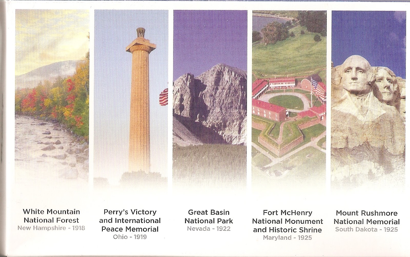
America The Beautiful Quarters Set – 2013:
This coin set includes the
fourth annual release of five quarters in the America and the Beautiful
Quarters programme, from the sixteenth to twentieth coin releases. This coin series
features a national park or site from each state, territory and the District of
Columbia. These coins are struck using greater force than circulating coins,
producing a sharp, intricately designed image.

The cover of the America and the Beautiful Quarters Proof set
showing the Mount Rushmore National Memorial.
 The Back of the above Proof set
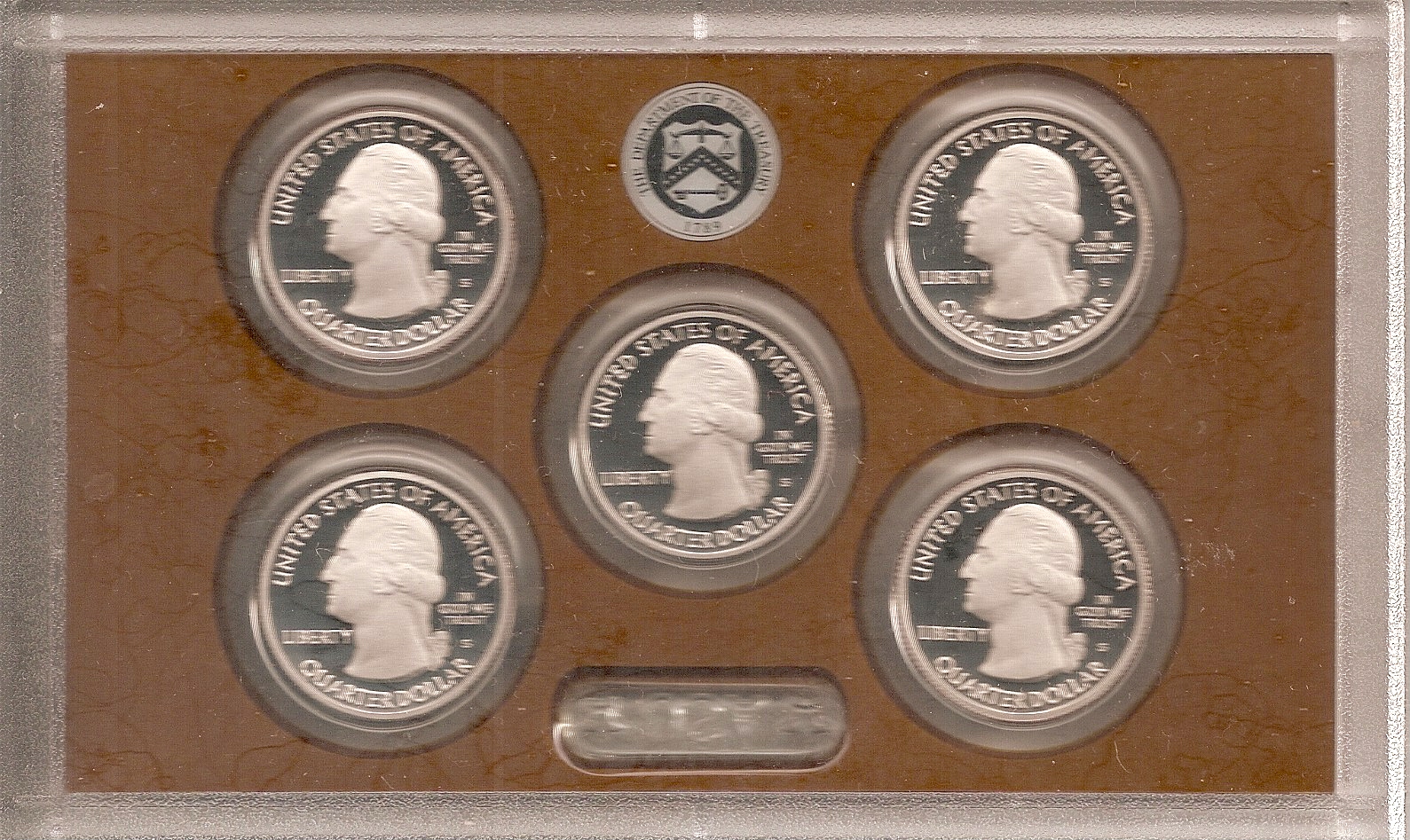 The obverse of the Proof set showing the image of George
Washington. Below the inscription "In God we Trust" is the
San Fancisco Mint mark "S" on each quarter.
The obverse of each quarter depicts the 1932 portrait of George Washington designed by John Flanagan, which has been restored to bring out subtle details and the beauty of the original model. The inscriptions on this face of the coin read “UNITED STATES OF AMERICA”, “LIBERTY”, “IN GOD WE TRUST” and “QUARTER DOLLAR”.
 The reverse of the Proof set showing the themes chosen for
the five Quarters issued this year.
The specifications of the Proof coins are:
The five "America and the Beautiful Quarters" coin set issued in 2013, represent White Mountain National Forest (New
Hampshire), Perry’s Victory and International Peace Memorial (Ohio), Great
Basin National Park (Nevada), Fort McHenry National Monument and Historic
Shrine (Maryland) and Mount Rushmore National Memorial (South Dakota).
The cover of the America and the Beautiful Quarters Proof set
showing the Mount Rushmore National Memorial.
Washington. Below the inscription "In God we Trust" is the
San Fancisco Mint mark "S" on each quarter.
The obverse of each quarter depicts the 1932 portrait of George Washington designed by John Flanagan, which has been restored to bring out subtle details and the beauty of the original model. The inscriptions on this face of the coin read “UNITED STATES OF AMERICA”, “LIBERTY”, “IN GOD WE TRUST” and “QUARTER DOLLAR”.
the five Quarters issued this year.
The specifications of the Proof coins are:
Metal Composition: Nickel:
83.33%, Copper: 16.67%;
Weight: 5.670 gms; Size
(Diameter): 0.955 inch (24.3 mm);
Edge: Reeded; Mint: San
Francisco.
Uncirculated Coin set - 2013:
For this year, the US Mint
has redesigned the folders which now display a red, white and blue flag image
on the front, as a coin has been issued on Fort McHenry this year which is
regarded as the birth place of the US National Anthem “The Star Spangled
Banner”.
The Philadelphia folder is accented in blue,
while the Denver folder is accented in red.
 The cover of the Denver Folder accented in red


Denver Mint Uncirculated coin set 2013 showing the "D" mint Mark.


The specifications of the
Uncirculated "America and the Beautiful Quarters" coins are:
Metal Composition: Copper:
91.67%, Nickel 8.33%
Weight: 5.567 gms; Size
(Diameter): 0.955 inch (24.3 mm);
Edge: Reeded; Mints
:Denver, Philadelphia.
White
Mountain National Forest in New Hampshire:
The White Mountain
National Forest (WMNF) situated within the White Mountains in New Hampshire
partially spills over into the State of Maine.
It is one of America’s
most visited National Forests for its wide array of recreational opportunities
and rich Natural resources and unique and strikingly beautiful landscapes. The
WMNF includes unique features such as Mt. Washington, the highest peak north of
the Smokey Mountains and East of the Mississippi. It was established as a
National site on 16.05.1918.
It has a total area of
3039 sq.kms. It is a popular destination for hiking, camping and skiing. The
WMNF has about 1900 km. of hiking trails, 23 campgrounds and large number of
Ski areas. Over 160 km. of the Appalachian Trail traverses the WMNF.
The National Forest
consists of 3 main Areas: one, the Region surrounding Cannon Mountain,
Kinsman Mountain and Mount Moosilauke, two, the Presidential Range area
and three, the Franconia, Twin, Bond, Sandwich, Willey and Carter-Moriah
ranges.
The WMNF also has six
designated Federal Wilderness Areas within the Forest:
The Presidential
Range/Dry River Wilderness, the Great Gulf Wilderness, the Pemigewasset
Wilderness, the Sandwich Range Wilderness, the Sandwich Range
Wilderness and the Wild River Wilderness.
Mount
Chocorua, named after a Native American in the 18thCentury, is situated at about 1064 metres and is the easternmost peak of the
Sandwich Range in the White Mountains.
Chocorua’s summit is a
picturesque rocky cone and the mountain is said to be one of the most photographed in the world from the Chocorua Lake
because the mountain top casts a perfect reflection in the Lake.
The
Commemorative coin:
The White Mountain
National Forest (WMNF) quarter is the
first of 2013 and the 16th overall in the America and the Beautiful
Quarters Programme.


Perry’s
Victory and International Peace Memorial in Ohio:
The
Memorial:
Perry’s
Victory and International Peace Memorial located near
Ohio’s South Bass Island, commemorates the Battle of Lake Erie, which was one
of the most significant naval battles of the War of 1812.
It also celebrates the
lasting peace between Britain, Canada and the United States, that followed the
war. The memorial site was established to honour those who fought in the Battle
of Lake Erie and bears the name of Master Commandant Oliver Hazard Perry.
The International Peace
Memorial is the World’s largest Doric column, measuring 352 feet and was
constructed from 1912-1915 in Put-in-Bay Ohio. It stands 47 feet taller than
the statue of Liberty in New York Harbour. The upper deck platform is 12 feet
taller than the statue of Liberty’s torch.
The remains of three
American officers (John Brooks, Henry Laub and John Clark) and three British
officers (Robert Finnis, John Garland and James Garden) are buried beneath the
stone floor of the monument.
The Memorial was established
as a National site on 03.03.1919, declared a National Monument in 1936 and
redesignated as a National Memorial in 1972.
The
Battle of Lake Erie in the War of 1812:
The United States went to
war against Great Britain in an unprepared state. When war was declared on 18.06.1812, the British Navy
outnumbered the U.S. Navy 17 to 1.
Perry’s fleet had
successfully blocked the British supply route from Fort Malden to Port Dover,
leaving the British with no choice other than to abandon Fort Malden or put up
a fight.
The British squadron
commanded by Commander Robert Heriot Barclay (who had fought at Trafalgar with
Lord Nelson) consisted of six ships with sixty-three cannon, while the American
flotilla had nine ships fitted with fifty-four cannon.
The British cannon were
long range guns which could throw cannonballs up to one mile, while the
American fleet had carronades which could fire for about half of that distance
and could inflict severe damage only at close range.
On 10.09.1813, when
the British fleet was spotted, Perry’s squadron sailed from Put-in-Bay harbour at
7.00 a.m. Perry’s best bet was to sail with a favourable wind to close the
distance between the two fleets so that his guns could rake the enemy ships,
but the wind stayed unfavourable. Just before Perry issued orders to his fleet
to scuttle the engagement, the wind turned favourable to Perry’s advantage.
Perry’s battle plan was that the American
schooners “Ariel” and “Scorpion” were to be placed off the Flagship’s weather
bow to engage the first British ship, so as to prevent the enemy from raking
the US Flagship, the “Lawrence”, a 20 gun brig, which sailed third in line, and
which was to engage the “Detroit” a British 19 gun flagship.
Fourth in line was the “Caledonia”,
a small brig with three guns. Fifth in the American line of battle was the “Niagara”
a 20 gun Brig and the Lawrence’s sister ship which was to engage the “Queen
Charlotte” a 17 cannon and the second largest ship in the British Fleet. The
last in the American battle formation were smaller schooners and a sloop which
were to engage the smaller British vessels.
Perry hoisted his battle
flag with the message inscribed on his flag “DON’T GIVE UP THE SHIP”. These
were the dying words of a fallen comrade Captain James Lawrence, in whose
honour Perry’s Flagship was named.
The “Detroit” opened fire
first, striking the Lawrence and injuring a few American sailors. The American
ships were still far out of firing range, nevertheless, the “Scorpion” with one
long 24 pounder and the “Ariel” with four long 12 pounders returned the fire.
Perry’s flagship struggled to get within close range but suffered severe damage
as it was raked by three enemy ships.
The smaller American schooners
and the sloop fell far behind upto two km despite their best efforts and were
temporarily out of the battle.
Perry manoeuvred to get up
close to the British ships and the “Lawrence” fired a broadside volley of 32
pounders, from its starboard guns severely damaging the British ships. The “Niagara”
which was sailing closely behind the Lawrence and was supposed to follow up the
advantage gained by the American Flagship, instead of closing in, shortened its
main sail which held the ship dead in the water because the Captain’s orders
were to hold his position in the line of battle.
The “Caledonia commander”
too shortened its sails unwilling to engage the vastly superior “Queen
Charlotte” whose vastly superior broadside would cripple his ship. At this
point the Niagara Captain shifted out of the rigid “line of battle” tactic and sailed
away from the British ships, as his guns were still out of range and he too feared
severe damage from the British ships.
Presuming that the
American fleet was on the run, the “Charlotte” and “General Hunter” once again
started pounding the isolated Lawrence which by now was completely overwhelmed
by superior firepower and became a floating wreck with 80% of its crew killed
or disabled.
 Perry leaving the Lawrence for taking command of the Niagara in one of the Flagship's cutters. This image is from "An outline of American History" received by my father (Late) Dr. J.N. Prasad from the United States Information Service in December 1983.
 A Forever Stamp was issued by the US Postal Service commemorating Perry's heroic feats in the Sea Battle of Lake Erie in the War of 1812, in 2013 to celebrate the bicentennial of the Battle.
Perry saw that the Niagara
was still out of range and collecting four able bodied men, he rowed in one of
the Lawrence’s cutters under withering fire to reach the Niagara. The Niagara’s
petrified Captain who had been reluctant to engage in battle seeing the fate of
the Lawrence, was despatched in the same cutter to get the lagging smaller ships
to hasten to the battle theatre.
Meanwhile, the Lawrence
with its remaining firepower and men continued to pound the British ships like
a wounded lion and they too suffered terribly in the exchange.
Perry sailed the Niagara
into the British fleet, firing both broadsides. He shortened the main topsail holding
the Niagara stationary, while her carronades demolished the enemy decks. The
sluggish gunboats meanwhile reached the scene of battle and raked the enemy
from the other side.
The entire British fleet
consisting of two ships, two brigs, one schooner and one sloop had been
captured.
The battle of Lake Erie
proved to be one of the most resounding triumphs of the US Navy. It forced the
British to abandon Fort Malden and retreat far back upto the Thames River where
they were decisively defeated in the Battle of the Thames. Both the victories
of Lake Erie and the Thames ensured that the States of Ohio and Michigan would
remain Sovereign territories of the USA.
The bicentennial of the
victory fell in 2013 and is being celebrated at the Memorial, with tributes to
Perry and his brave men who fought on that day.
The
Commemorative coin:
Perry’s Victory and
International Peace Memorial quarter is
the second of 2013 and 17th overall in the America and the Beautiful
Quarters Programme. 

Great
Basin National Park (GBNP) in Nevada:
Location
and Attractions:
GBNP is located in
East-Central Nevada near the Utah border and takes its name from the dry and
mountainous region between the Sierra Nevada and the Wasatch Mountains. It is
located about 470 kms north of Las Vegas.
It was originally created
by a Presidential proclamation on 24.01.1922 as Lehman National Caves National Monument and was incorporated
into the National Park in
1986.
GBNP has exceptional
geology, biodiversity and scenic grandeur.
GBNP is like an oasis in
the desert with more than 40 miles of perennial streams and 400 springs. The
park also contains a variety of cultural resources dating back to prehistoric
times, as well as structures and sites related to mining, western surveys and
ranching.
Native
Americans settled the Great Basin some 10000 years
ago.
Several distinct tribes
have historically occupied the Great Basin. Some of them are the Western
Shoshone (a sub-group of Shoshone), the Goshute, the Ute, the Paiute and the
Washoe.
The
Fremont culture:
Remnants of an
archaeological culture called “Fremont”,
(named after the Fremont River in Utah) have been discovered. The Fremonts
differed from their famous contemporaries in the 11th to 14thcentury, the ancestral Puebloan people who built Mesa Verde and the Chaco
Canyon.
The Westernmost Fremont
site, Baker village is
located a few miles from the GBNP. It is an organised cluster of over 15
buildings built to a specific plan and aligned to a single compass direction.
In the centre, a larger mud-walled structure shows interesting alignments with
sunrise on the winter and summer solstices.
The Fremonts culture had a
very unique “one rod and bundle” basketry construction, moccasins made from the
hock of deer or sheep leg, trapezoidal shaped figures found as clay figurines
and in rock art, and the unique materials used to make gray coiled pottery.
Fremont people left Art on the rock walls at Upper Pictograph Cave.
Fremont culture
disappeared sometime between 1300-1500 A.D. This is the period when the Pueblo
cultures seem to have forced the Fremonts out of the area.
Early
Pioneers:
Early pioneers arrived in
the great basin in the 1800s. Ranching became a livelihood and mainstay for
settling the region. Land and public land grazing permits were accorded to the
Ranchers. Even with the creation of GBNP in 1986, grazing within the Park
continued under permit which has raised several objections from the tourists.
The
Lehman Caves:
The Lehman Caves are about
550 million years old and made of marble and limestone which form the most
heavily decorated limestone solution caverns in the Western US. These natural
cave decorations are found throughout the caverns.
The Caves (named after
Absalom Lehman – 1827-1891 – who was variously a gold miner in California and
Australia, rancher, politician etc. who owned several pastures, orchards,
cultivated fields, stables, blacksmith, carpenter, butcher shops etc. He not
only helped settle the area with several families coming in to live there, but
also developed the caves which were near his ranch into a tourist attraction by
1885) at the base of Wheeler Peak,
the second highest peak in Nevada. Around the Wheeler Peak, 4000 to 5000
year old bristlecone pine trees grow on rocky glacial moraines.
GBNP also has the Lexington Arch, one of the
largest limestone arches in western United States. This type of above ground
limestone arch is rare. This six-storey arch was created by Natural forces over
the millennia.
Flora
and Fauna of the GBNP:
The Park is known for its
groves of ancient bristlecone pines. A bristlecone pine tree-trunk cut down for
research purposes, known as “Prometheus”
contained 4700 rings, indicating that the tree was 4700 years old.
The park is home to 11
species of conifer trees and over 800 species of plants, including sagebrush,
saltbush, single-leaf Pinyon and the Utah juniper.
There are 61 recorded
species of reptiles, 238 species of birds, 2 species of amphibians and 8
species of fish in the GBNP area, including jackrabbits, pygmy rabbits,
mountain cottontails, ground squirrels, chipmunks, coyotes, badgers, mountain
lions bobcats, mountain sheep, mule deer, spotted skunk, ringtail cats etc.
Bird species include the hawk, sparrow, wren, chickadee, eagle, magpie, swallow
etc.
The Bonneville cutthroat
trout is the only trout native to Great Basin National Park and have been there
from some 18000 years ago.
Aspen
Art or Arborglyphs:
Aspen trees throughout the GBNP bear carvings
known as arborglyphs, dendroglyphs or aspen Art, a practice which started in
the late 1800s by Basque sheepherders and later continued by Peruvian sheepherders.
Recreational campers and cattlemen also followed the practice, which has since
been prohibited by Park Authorities.
Some interesting insights into the life and
cultures of the people who have made these carvings have been recorded. Aspens
have a life span of 70-100 years. These aspen carvings have helped establish
dates as to when the carvings were made and find out the carver’s names and
their home-towns and countries. This has helped archaeologists in establishing
the history of land use for the Area. GBNF has documented the information
culled from these carvings since 2006.
The Park has 12 Nature Trails – the shortest
being Mountain View Nature trail (6825 feet) and the longest being Wheeler
Summit trail (10,160 feet).
The
Commemorative coin:
Great Basin National Park
(GBNP) quarter is the third of 2013 and the 18th overall in
the America and the Beautiful Quarters Programme.


A quarter received in general circulation, inscribed "Great Basin" and showing the above-mentioned features.
Fort
McHenry National Monument and Historic Shrine in Maryland:
The
introduction:
Fort McHenry, named after
a Scots-Irish statesman James McHenry (1753-1816), USA’s second Secretary of
War, is situated in Baltimore, Maryland and is a star shaped fort which played
a significant role in the War of 1812.
It was built between 1798
and 1800 in the form of a five pointed star surrounded by a dry moat. In the
event of an attack, each point was positioned to provide a cross fire on the
attacking troops. The Fort successfully defended Baltimore Harbour against the
British Navy in Chesapeake Bay on 13-14.09.1814.
The
War of 1812 – The Defence of Fort McHenry:
The British believed that Baltimore
was a vital port from where privateers were attacking their shipping.
Accordingly, after the successful ransacking/burning of Washington, a
two-pronged attack on Fort McHenry was planned with Major General Robert Ross
landing at North Point and advancing overland, while Vice Admiral Sir Alexander
Cochrane would attack the Fort and harbour defences from the Sea.
The Fort was defended by
1000 men under Major General Samuel Smith and Garrison Commander Major George
Armistead and had 20 guns at their disposal. In addition, it also had batteries
at several strategic points outside the Fort, which were positioned to hamper
the enemy advance, in addition to about 12000 irregulars from Baltimore City.
The British Navy under
Cochrane had 19 ships and 5000 men.
Ross had 4500 soldiers at
his disposal.
On 12.09.14, on one front, Ross landed at
North Point and encountered American forces under Brigadier General John
Stricker whose main objective was to delay the British forces while the Fort reinforced
its fortifications. Ross was killed and his forces took heavy casualties.
Leaderless, they preferred to remain on the field through the night under
Colonel Arthur Brooke.
Brooke in the morning of
13.09.1814 advanced towards the city and was stunned to encounter a force of about
12000 American irregulars behind substantial earthworks east of the city.
Under orders only to
attack the Fort only if he had a good chance of success, he was forced to hold
his line without any success.
On the other Front, from 6.00 A.M. on 13.09.1814, the British
warships began to continuously bombard the Fort for the next 25 hours, although
hampered by the shallow waters, they managed to stay out of range of the Fort
guns.
The Fort had 18, 24 and 38
pounder cannon with a maximum range of 1.5 miles (2.4 km). The British guns had
a range of 2 miles (3 km) and their rockets could go up to 1.75 miles (2.8 km).
The British guns despite their long distance fire-power could not take Fort
McHenry and penetrate the defences which included a chain of 22 sunken ships,
apart from the cannon defending the Fort.
Due to lack of accuracy of
the British weapons and the limited range of American weapons, very little
damage was done on either side before the British ceased firing on the morning
of 14.09.1814 due to lack of ammunition.
Only one British warship
received a direct hit from the Fort’s fire which wounded one crewman. On the
American side the casualties were four dead and 24 wounded in the cannonade.
In between, an assault force of 1200 men from the
ships, in small boats rowed ashore and thinking that they were safe,
fired signal rockets which gave away their position. They had to withdraw after
taking heavy casualties from Forts Covington and Babock near the Fort McHenry,
where they were not expecting any defences.
On the ground, the consolidated
British losses were heavy with about 330 casualties - killed, wounded or captured.
By the evening, Armistead
lowered the Fort’s small storm flag and replaced it with a standard garrison
flag measuring 42x30 feet clearly visible to all ships in the river indicating
that the Fort had been successfully defended on all fronts.
Cochrane became disheartened and withdrew from the
engagement. On shore, Brooke too decided to back off instead of attempting a
suicidal attempt to breach the American defences.
The Fort was, thus,
successfully defended which was an important morale booster for the Americans
after the burning of Washington D.C. by the British.
The
American Flag flying at Fort McHenry after the successful defence inspires the
composition of The US National Anthem “The Star Spangled banner”:
Francis Scott Key, a
poet-lawyer witnessed the September 13-14 bombardment of Fort McHenry while
under British Guard on an American truce ship in the Patapsco River, on seeing
the American flag still flying over the fort the next morning composed the poem
“The Defence of Fort McHenry” which was, later, renamed “The Star Spangled
Banner” and became the US National Anthem.
Fort
McHenry: A National Memorial:
Fort McHenry was placed on
the National Register of historic Places on 15.10.1966 and established as a
National site on 03.03.1925. The first official 49 and 50 star American Flags
were hoisted at the Fort and are still located on the premises.
The Fort is a prominent
Tourist attraction, as thousands of visitors flock every year to see the
birthplace of the Star Spangled Banner.
Every September, Baltimore
commemorates “Defender’s Day” to honour the memory of the brave men who fought
in the battle. The bicentenary celebrations are scheduled to commence in
September 2013.
The
Commemorative coin:
Fort McHenry National
Monument and historic Shrine quarter is the fourth
of 2013 and the 19th overall in the America and the Beautiful Quarters
Programme.


Mount
Rushmore National Memorial in South Dakota:
The
controversy over the name of the Mountain:
This mountain was earlier
known to the Lakota Sioux as Six
Grandfathers. The mountain was part of the route that Lakota Chief Black
Elk took in a spiritual journey that culminated at Harney Peak.
From 1876 to 1878,
a series of military campaigns were undertaken by the US Army to assert control
over the Area, an action which is still disputed, as the Treaty of Fort Laramie
had granted the Black Hills to the Lakota in perpetuity.
Early American settlers
called the mountain Cougar Mountain, Sugarloaf Mountain, Slaughterhouse
Mountain and Keystone Cliffs.
It was named Mount Rushmore during a prospecting
expedition led by an attorney Charles Rushmore, who came to the Black Hills in
1884-85 to check legal titles on properties. As the mountain did not have a “confirmed”
name, the expedition named it after the attorney, and the name stuck for
posterity.
In pursuit of the Lakota
Indians claim, when the Mount Rushmore National Memorial was created in the
Black Hills, an American Indian Movement, accordingly, wanted to name this site
“Mount Crazy Horse” as a protest.
The Crazy Horse Memorial is now
being constructed elsewhere in the Black Hills to commemorate the famous Native
American leader as a response to Mount Rushmore through funding sponsored by
the Lakota Chiefs.
The
Memorial:
Mount Rushmore National
Memorial is a sculpture carved into the face of Mount Rushmore near Keystone,
South Dakota, USA. The Memorial is located 23 miles southwest of Rapid City.
It
was sculpted by Gutzon Borglum. Mount Rushmore features 60 foot (18m) granite sculptures
of the heads of four US Presidents. The sculptures are scaled to men who would
stand 465 feet tall. That makes each head as tall as a six-storey building.
The entire Memorial covers
1278.45 acres (5.17 km) and is 5725 feet (1745 m) above sea level.
Mount Rushmore receives
about 3 million visitors every year from across the World. The U.S. National
Park service took control of the Memorial in 1933. Over the years, Mount
Rushmore has grown in fame as a symbol of America – a symbol of freedom and
hope for people from all cultures and backgrounds.
It was first established
as a National site on 03.03.1925.
The
history of the Memorial:
In 1924, South Dakota
historian Doane Robinson is credited with conceiving the idea of carving the
likeness of famous people into the Black Hills region of South Dakota so as to
promote tourism. He accordingly, contacted Sculptor Gutzon Borglum to discuss
his proposal.
Several suggestions were
made to carve famous western personalities like Buffalo Bill, Lewis and Clarke,
Susan B. Anthony and Sacagawea.
But, a Special group, a
“Commission” instead chose these Presidents because they best represented the
“foundation, expansion and preservation of the United States.
The
significance of the selection of these four Presidents:
There has been
considerable debate on why Presidents George Washington (1st
President), Thomas Jefferson (3rd President), Abraham Lincoln (16th
President), Theodore Roosevelt (26th President) have been chosen to
have their sculptures carved out on Mount Rushmore. However, the influencing
factors over the selection were:
George
Washington (1732-1799): He led the colonists in the
Revolutionary War which won Independence from Great Britain. He is considered
to be the father of the new country and he laid the foundation of American
democracy. He thus becomes the most important personality to find a place on
Mount Rushmore.
Thomas
Jefferson (1743-1826): He was the author of the Declaration
of Independence, a document which inspires democracies around the world. He
also purchased the Louisiana Territory from France in 1803 which doubled the
size of the country, adding all or part of the present day fifteen states.
Abraham
Lincoln (1809-1865): He held the nation together during
the American civil War. He believed that his most sacred duty was the
preservation of the Union. It was also his firm conviction that slavery must be
abolished and he always worked towards that end.
Theodore
Roosevelt (1858-1919): He provided leadership when America
experienced rapid economic growth as it entered the 20th Century. He
was instrumental in negotiating the construction of the Panama Canal, linking
the east to the west. He was known as the “trust buster” for his work to end
large corporate monopolies and ensure the rights of the common working man.
In the words of the
Project Sculptor Borglum, “The purpose of the memorial is to communicate the
founding, expansion, preservation and unification of the United States with the
colossal statues of Washington, Jefferson, Lincoln and Roosevelt.”
Over the years, Mount Rushmore
has grown in fame as a symbol of America – a symbol of freedom and hope for
people from all cultures and backgrounds.
The
execution of the Project:
After obtaining due
permission through Congress and South Dakota Legislature, Borglum found it
difficult to get the project started due to lack of funding. He managed to rope
in President Calvin Coolidge who in the dedication ceremony promised federal
support for the project.
Borglum wanted to limit
the Federal Funding to half the project cost, as he was confident that private
funding/donations would meet the other half. Strangely, while, Robinson had
mooted the project, he was sidelined in the actual execution and management of
the project.
From 04.10.1927 to
31.10.1941 about 400 workers worked hard at building the Memorial. Workers
had to endure conditions varying from blazing hot to bitter cold and windy.
They had to climb 700 steps to the top of the mountain from where 3/8 inch
thick steel cables would lower them over the front of the 500 foot face of the
mountain in a “bosun chair”.
About 90% of the mountain
was carved by placing charges of dynamite of specific sizes to remove precise
amounts of rock. Dynamite was used until only three to six inches of rock was
left to remove to get to the final carving surface. At this point, the drillers
and assistant carvers drilled holes into the granite very close together in a
“honeycombing” pattern.
After the honey combing
operation, the workers smoothed the surface of the faces with a hand facer or
bumper tool and air hammers. As a last step, the bumper tool would even the
granite, creating a smooth surface.
Washington’s face was
completed in 1930, Jefferson in 1936, Lincoln in 1937 and Roosevelt in 1939.
The initial plan was to depict the four Presidents from head to waist, but
because of lack of funding construction was forced to end in October 1941. Just
before a final dedication of the Project Borglum died.
His son Lincoln Borglum
completed the remaining project thereafter on 31.10.1941.
Visitors, during the
execution of the Project, in their zeal to possess a part of this historical
memorial as a special souvenir paid up to six dollars after hard bargaining
with the workers.
There was, also, a plan to
carve the head of Civil Rights leader Susan B. Anthony, but a rider was passed
on an appropriations bill requiring Federal funds to be used to finish only
those heads that had already been started at that time. The entire project cost
a little less than US$ 100000.
Interestingly, no worker
died during the carving.
The
commemorative coin:
The
Mount Rushmore National Memorial (MRNM) is the fifth quarter of 2013 and the 20th
overall in the America and the Beautiful Quarters Programme.

Mount Rushmore has earlier
featured on three 1991 Mount Rushmore Golden Anniversary Commemorative Coins
and on the 2006 South Dakota quarter issued under the 50 State Quarters
Programme.
This new design is
distinctly different and offers a unique and educational perspective on how
Mount Rushmore was created and sculpted. The inscriptions on the periphery are
“MOUNT RUSHMORE, SOUTH DAKOTA, 2013” and “E.PLURIBUS UNUM” (“One out of many”).

 The above is the reverse of a State quarter issued for South Dakota in 2006, under the State Commemorative quarters programme. Mount Rushmore is the only National Memorial to figure on the reverses of both the State commemorative quarter as well as the America the Beautiful quarter.
A quarter received in general circulation, depicting the above-mentioned features.
The
Hall of Records – An abandoned project:
A man-made opening called
the “Hall of Records” was created in the mountain behind the heads on Mount
Rushmore. Gutzon Borglum and his carvers worked on the Hall of Records from
July 1938-1939, but it was never finished.
A chamber cut 70 feet (21
m) into the rock, there is a vault with sixteen porcelain enamels panels. The
panels include the text of the Declaration of Independence and the
Constitution, biographies of the four Presidents and Borglum and the history o
the US. The chamber was created as the entrance-way to a planned “Hall of
Records”; the vault was installed in 1998.
Interesting
titbits on the Mount Rushmore National Memorial:
- Geologists
estimate that the granite at Mount Rushmore National Memorial will erode about
one inch only every 10000 years.
- Since
its completion in 1941, Mount Rushmore has joined the Statue of Liberty and the
Stars and Stripes as one of America’s most inspiring symbols of democracy.
Links:
6) Susan B. Anthony : One dollar coin issued in honour of the Women's Rights Activist
7) State Commemorative Quarters
8) America The Beautiful Quarters - 2014
9) Westward Journey Nickel series 2004-2006
10) New $ 100 Bill with Additional Security Features
11) The Strange Case of me becoming a US Citizen, without even applying for it, thanks to the US Mint
12) America the Beautiful Quarters Programme - 2015
13) US Bicentennial Coins
14) Forever stamps: Commemorating the 150th Anniversary of the US Civil War 1861-1865
15) Commemorating the 225th Anniversary of the U.S. Marshals Service with coins
16) American Gold Buffalo Coins
17) American Gold Eagle Coins
18) America the Beautiful Quarters - 2016
No comments:
Post a Comment